There’s a lot of overlap between this credit and IPc1: Integrated Process, but while IPc1 is geared towards planning building services, the focus of this credit is on ecology, hydrology, and the social value of the site.
Developing a deep understanding of your site’s opportunities and challenges early can inform design strategies that might otherwise be overlooked. This credit itself is worth only one point but can influence many components of the LEED application. In fact, aside from IPc1, it probably benefits achievement of sustainable strategies on more credits than any other.
Site assessment synergies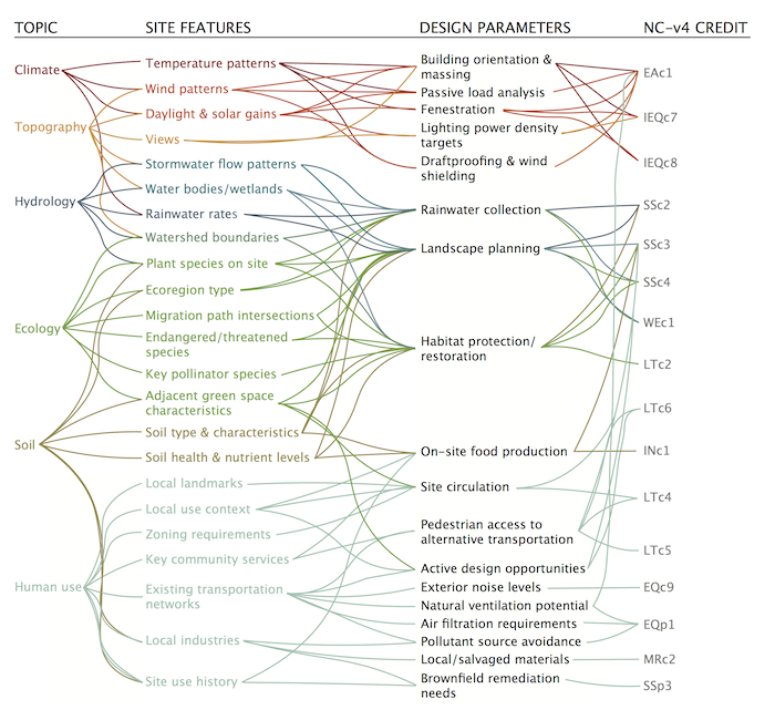
Any project is eligible to earn this credit, and any project can benefit from incorporating site-related goals into the integrative design process. These common opportunities for analysis are only a starting point—thinking about how to adapt this exercise to the specific context of your project will gain the best results.
Based on SITES prerequisite
The credit, new in LEED v4, is inspired by and adapted from a prerequisite in the Sustainable Sites Initiative (SITES), a rating system that encourages sustainable land use and landscaping practices. The program resources for SITES are a great starting point for understanding the intent of performing a site assessment. Here we present some strategies on how to successfully leverage a site assessment for LEED projects.
Gather the team
There are no formal requirements for who should be involved in the site assessment. Many project team members can contribute, including:
- Civil engineer: Can advise on hydrology and topography
- Architect: Can help guide the process; can provide information on important views, materials, and project goals; and can incorporate feedback into the building design
- Landscape designer: Can advise on ecology, soils, and climate; can suggest opportunities for low-impact development strategies
- MEP: Can provide information on climate and incorporate feedback into building systems selection
- Energy modeler: Can provide information on climate and solar gain; can use assessment results to help evaluate building systems selection
- Community stakeholders: Can provide information on important landmarks, nearby uses, previous site uses, and needs for transportation connections and amenities
- Owner: Can advise on project goals and requirements; can incorporate assessment results into decision-making
This assessment also can be used to invite specialized expertise onto the team. Getting the perspective of an ecologist during the planning phase, for example, can substantially influence the extent to which site considerations are reflected in the final project.
Make it meaningful, together
The main credit requirement is to complete a site survey or assessment report. It could be tempting to assign this work to individual team members and split up the report along lines of expertise, but don’t do it!
The site assessment is a great opportunity for cross-collaboration, and compiling the information early with joint consideration of project team members is where the assessment adds value to the project.
Start looking for synergies in each aspect of the analysis as soon as a site is selected and develop shared goals based on overlapping topics. For example, the soil type of your site is critical for understanding how stormwater will behave, so you will likely need to compile information on soil type, rainfall frequency, and runoff rates.
That same information could help evaluate appropriate plantings with low maintenance requirements. Selecting appropriate plants would in turn improve stormwater management, and also expand habitat opportunities for nearby species. Understanding the linkages will help avoid duplication of effort and capture the full impacts of site decisions.
Consider some guiding questions
Ideally, the content of the site assessment should be tailored to both the context and the project’s general goals. Some considerations will apply to certain types of sites but not to others. Expand upon or modify this list of guiding questions as the assessment progresses.
Vegetation and Soils
- What plants are currently growing on the project site? Are they well suited to the soil and weather? Are they considered invasive or detrimental to native flora and fauna?
- Do any significant trees exist onsite that merit protection?
- Is the soil healthy enough to support food production? Is there extensive compaction or potential contamination?
- Is the site home to any particular animal species? Is it on any migration paths? Do threatened or endangered species use or travel through the site or region?
Hydrology
- What does the site look like when it rains? Is there any recurring flooding? How does water flow across the site?
- Are there seasonal patterns to precipitation?
- Is the site in or near a flood zone?
- What is the health of the groundwater table under the site?
- Are there local bodies of water that the site drains into? If so, how near are they? Are there any existing pollution issues in these water bodies?
- Are there opportunities to reduce impervious surfaces within the site boundary and increase onsite infiltration
Topography and Climate
- Are there seasonal temperature patterns? Is one season longer or more intense than the others?
- How much sunlight does the site receive? Is the area frequently cloudy or rainy? Are there any large trees or neighboring buildings that shade portions of the site?
- When is direct sunlight desired to heat the building, and when is it a problem?
- What are the best view corridors? Are there major points of visual interest to highlight?
- Are there any strong prevailing winds on the site? Are these desired for cooling and ventilation, or will they add to building loads?
Community Connections
- Is the surrounding area developed or undeveloped?
- Are there particular transit connections or services that will be important to users of the project building?
- Are there any air pollution sources such as highways or factories nearby?
- What are the existing opportunities for outdoor recreation and enjoyment? How can the project support or improve these opportunities?
- What are the long-term goals of the community, and how does the project fit with these goals?
- What is the natural material palette of the site and neighboring buildings? What materials would help connect the building to its place?
- Where are the nearest sources for building materials? Are there any opportunities for salvaged materials or local reuse/recycling centers?
Will it cost you—or save you money?
Due to strategies identified or explored through the assessment process and cost synergies with other LEED credits, this credit is more likely to produce cost savings than added costs. Any added costs would be associated with time spent during design. Assessments like these are usually required on large commercial projects and are often carried out by the owner or included in the design team’s contract and do not represent an added cost.
What’s New in LEED v4.1
- Minor modifications and clarifications have been made throughout the credit language. The most substantive revisions are to the hydrology, vegetation, and soils sections.
Should I Upgrade?
Although the differences are fairly minor, v4.1 provides some clarifications that might help you ask the right questions and engage the right team members as you complete the site assessment.